
What to See and Do in Santa Maria di Leuca, Where Two Seas Meet
By Eugenio TommasiUpdated 19 August 2026 7 min read
Key facts
- Best for
- The southern tip of Salento, where the Adriatic and Ionian meet, marked by a lighthouse, a fortified basilica and a monumental staircase down to the harbour
- Time needed
- Half a day for the lighthouse, basilica, Cascata Monumentale and a walk along the seafront; a full day with the sea caves at Punta Ristola or the ride down from Otranto
- Getting around
- On foot around the harbour and the upper town; bike or car for the wider coast and the caves at Punta Ristola
- Indicative cost
- The lighthouse headland and the Cascata Monumentale are outdoor and free; the basilica is open daily 06:30-21:00 with no admission charge published. Entry conditions for the sea caves weren't confirmed on an official source, so treat any cave visit as a planning estimate and check locally before you go
- Distance from Lecce
- 70 km (43 miles), verified 19 August 2026; about 1h15 by car, too far for a comfortable round trip by bike in a day
- Distance from Brindisi Airport
- 125 km (78 miles) by road, about 2 hours by car — verified 19 August 2026 on two independent OSRM routing servers
- When to go
- April-June and September-October for mild weather and quieter streets; swimming season runs roughly June-September
Santa Maria di Leuca: where two seas meet
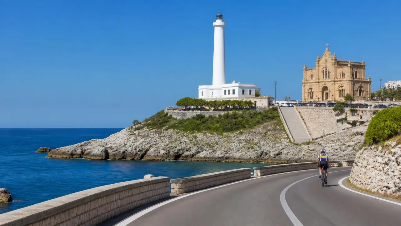
Santa Maria di Leuca sits at the southern tip of the Salento peninsula, in the comune of Castrignano del Capo, where the coast turns from the Adriatic on the east side to the Ionian on the west. The Adriatic side ends at Punta Meliso, marked by the lighthouse below; the Ionian side ends at Punta Ristola, a short stretch further round the headland. It's a stretch of coast rather than one exact line in the water, but the framing holds: this is genuinely where Italy's east and west coasts join.
The town itself is small: a harbour, a short seafront lined with early 20th-century villas, and a steep run of streets and a staircase climbing from sea level up to the basilica and lighthouse. Everything below sits within this compact area. Lecce is 70 km (43 miles) inland — see Seeing Santa Maria di Leuca by bike below for how that distance, and the coast road most cyclists use instead, work in practice.
Riding this route on one of our bikes? Start from our rent a bike in Puglia — delivery, sizes and prices are all there.
The tip of Salento, sight by sight
Faro di Punta Meliso
What it is
an active lighthouse on Punta Meliso, first activated in 1866. The tower is 48 m (157 ft) tall and its light sits 102 m (335 ft) above sea level, flashing white three times every 15 seconds with a nominal range of 24 nautical miles — figures published by the Marina Militare, which operates it as lighthouse 3590 (verified 19 August 2026).
Why it's worth it
the working navigation light that marks this coast, on the Adriatic side of the headland — a functioning structure, not a viewpoint dressed up as a landmark.
Practical
the tower isn't generally open to climb; the Marina Militare publishes no visiting programme for the interior, and we haven't found confirmation of any occasional public openings, so check the official site for the current situation before you go. The headland and approach path are publicly accessible.
Getting there by bike
a short, steep climb up from the harbour past the basilica, a few hundred metres on paved road, flat once you're on the headland.
- First-hand tip: the view back down over the harbour and the Cascata Monumentale, from the path just below the lighthouse, takes in most of this guide in one frame.
Basilica di Santa Maria de Finibus Terrae
What it is
the town's sanctuary church, rebuilt between 1720 and 1755 by Monsignor Giovanni Giannelli, who gave it a fortified appearance to withstand Ottoman and Saracen raids. It was raised to the rank of Basilica minore on 7 October 1990 — both facts published by the Comune di Castrignano del Capo (verified 19 August 2026). A painting attributed to Jacopo Palma il Giovane hangs over the main altar.
Why it's worth it
it reads as a fortress as much as a church — thick walls and a defensible plan, built for a coastline raided regularly through the 18th century.
Practical
open daily from 06:30 to 21:00, per the sanctuary's official site (verified 19 August 2026); no admission charge is published. The sacristy, where visits and Masses are booked, is open 09:30-12:30 and 16:00-18:00, extended to 17:00-19:00 in summer. Opening hours change seasonally — check the official site before you go.
Getting there by bike
on foot at the top of the headland, a short walk from the lighthouse and the top of the Cascata Monumentale's staircase; leave bikes near the harbour.
- First-hand tip: approach from the staircase side rather than the road — it lines the basilica up against the sea below in a way the road entrance doesn't.
Cascata Monumentale
What it is
the terminal works of the Acquedotto Pugliese (Apulian Aqueduct), cut entirely into the rock above the harbour, running more than 250 m down the hillside and discharging 1,000 litres of water a second into the sea. A large Roman column brought from Rome stands at the top of it. Construction of the aqueduct was interrupted by the First World War, and the Grande Sifone that carried water as far as Lecce was finished in 1927 — all per the Comune di Castrignano del Capo (verified 19 August 2026). Sources differ on the year the terminal works were inaugurated, and we haven't found an official date to confirm it, so we've left that detail out.
Why it's worth it
an unusual kind of landmark — built to mark the arrival of piped water from hundreds of kilometres north, not a war memorial or a shrine, physically linking the harbour to the upper town.
Practical
the Comune describes it as an open-air monument accessible to everyone, so the staircase and the structure can be walked at any time, free. The water itself does not run continuously: the Comune announces aperture straordinarie on set dates and at set times — the last published run was over the 2025 Christmas period and Epiphany, at 16:00 or 17:00 on each announced day. Check the Comune's news page for the current dates before planning a visit around the water.
Getting there by bike
right on the seafront, at the base of the climb to the basilica and lighthouse — impossible to miss on foot or by bike.
- First-hand tip: a paved road runs up the side of the hill for anyone who'd rather not take the staircase — useful if you've got a bike with you.
The liberty-style villas along the seafront
What it is
a run of Art Nouveau (liberty-style) villas along the seafront, built from the late 19th century — published accounts count roughly 43 by the turn of the century, though we haven't found an official source confirming the architects involved. Several were requisitioned in the Second World War to house evacuees and lost decorative ironwork to wartime metal collection; a number survive today.
Why it's worth it
a concentration of early 20th-century seaside architecture unusual for this coast, where most towns are built in plain local stone.
Practical
private residences today, best treated as viewing-only from the seafront road rather than sites open to visitors.
Getting there by bike
on the lungomare itself, between the harbour and the edge of town — flat, a couple of minutes end to end.
- First-hand tip: easier to take in slowly from a bike than a car — the seafront road is short enough to ride at walking pace and still catch the detail on each facade.
Grotta del Diavolo and Grotta Porcinara, Punta Ristola
What it is
two caves on Punta Ristola, the headland's westernmost point, on the Ionian side. The Grotta del Diavolo (Devil's Cave) runs about 40 m (131 ft) long and 17 m (56 ft) wide down to the sea; 1871 excavations found bones, shells, weapons and tools suggesting use since the Neolithic, now held in museums in Lecce and Maglie. The nearby Grotta Porcinara has inscriptions cut into its walls — dedications to Jupiter and ship names among them — read as evidence of use by sailors in antiquity. Not traced to a primary excavation report, so treat these details as historical background rather than confirmed fact.
Why it's worth it
the Ionian counterpart to the lighthouse side — Punta Ristola is the other point people mean when they say the two seas meet here, and the caves add archaeological depth rather than just scenery.
Practical
land access and any current restrictions weren't confirmed on an official source; boat trips run along this coast in season, so check current pricing and operators when you book, since we haven't verified them ourselves.
Getting there by bike
by bike or on foot, following the coast road west from the harbour to Punta Ristola — flat, a short ride from the centre.
- First-hand tip: this side faces sunset over the Ionian, while the lighthouse side faces sunrise over the Adriatic — worth timing a visit around whichever you'd rather see.
Seeing Santa Maria di Leuca by bike
Most cyclists reach Santa Maria di Leuca along the coast, not on the direct inland road from Lecce.
From Otranto, the way we know best: our guided Litoranea tour runs 52.6 km (32.7 miles) from Otranto to Santa Maria di Leuca, with 430 m (1,411 ft) of climbing on asphalt throughout — the SP358 provincial road, the last 8 km on the SP87, cresting around 125 m near Torre Nasparo and passing the Faro di Punta Palascia and Santa Cesarea Terme. Full detail on our bike tours in Salento & Lecce page. One caution: the Provincia di Lecce has an active roadworks project adding cycle-path sections along this stretch, so short diversions are possible while works continue.
Directly from Lecce: the road distance is 70 km (43 miles), mostly on the SS101 and then the SS274 Salentina Meridionale — a fast dual-carriageway built for cars, not a route we'd send a rider down for a relaxed day out. That's why we treat Santa Maria di Leuca as a drive from Lecce rather than a bike day trip, the same conclusion we reach in our day trips from Lecce guide. It works better as the finishing point of a longer coastal ride starting at Otranto or Gallipoli. From Gallipoli on the Ionian side, the direct inland road is 48 km (30 miles) and the longer way round the coast via Torre San Giovanni is about 61 km (38 miles) — both verified 19 August 2026 by OSRM routing on OpenStreetMap data, cross-checked on a second routing server.
Santa Maria di Leuca is also the planned southern end-point of the long-distance Ciclovia dell'Acquedotto Pugliese greenway. The 157 km leg from Grottaglie down to Leuca was still at the design stage in the Regione Puglia's last official update, so the greenway cannot be ridden into Salento yet — arriving from inland today means using ordinary roads.
Rent the right bike for whichever direction you're arriving from through bike rental in Lecce & Salento, or book the guided Litoranea day through bike tours in Salento & Lecce. For the wider regional picture, see cycling in Puglia.
How much time do you need in Santa Maria di Leuca?
| Time available | What you can realistically cover |
|---|---|
| 2-3 hours | The harbour, the Cascata Monumentale, the climb to the basilica and the Faro di Punta Meliso |
| Half a day | The above, plus a walk along the seafront villas and a coffee stop by the harbour |
| Full day | Old town and headland, plus a ride or drive out to Punta Ristola and the sea caves, or arriving via the Litoranea from Otranto |
Santa Maria di Leuca pairs naturally with the rest of the Salento coast on a longer trip — see our Salento travel guide for how it fits alongside Lecce, Otranto and Gallipoli, and the best places to visit in Puglia for how Salento compares with the rest of the region.
Getting to Santa Maria di Leuca without a car
There is no railway station at Santa Maria di Leuca. The Ferrovie del Sud Est network ends at Gagliano del Capo, whose station is named Gagliano Leuca — the southern terminus of FSE lines 3 (Novoli-Gagliano del Capo) and 6 (Gagliano del Capo-Zollino), per Regione Puglia. That station is about 8 km (5 miles) from Santa Maria di Leuca by road, verified 19 August 2026 by OSRM routing on OpenStreetMap data, so the last leg is by bus or taxi.
Coach lines cover the gap: the Provincia di Lecce's Salento in Bus network runs line 107 (Lecce-Maglie-Tricase-Santa Maria di Leuca) and line 108 (Lecce-Gallipoli-Santa Maria di Leuca). Check current routes and timetables on the official FS Sud Est site and the Provincia di Lecce's bus pages before planning around public transport, since schedules change seasonally.
By road, Santa Maria di Leuca is 70 km (43 miles) from Lecce, about 1h15 by car, and 125 km (78 miles) from Brindisi Airport, about 2 hours — both verified 19 August 2026 by OSRM routing on OpenStreetMap data. Allow more in July and August. If you're arriving by bike, see Seeing Santa Maria di Leuca by bike above.
FAQ
What is the best time of year to visit Santa Maria di Leuca? April-June and September-October give mild weather and quieter streets. July-August is busy and hot, with the seafront and harbour at their fullest; swimming season runs roughly June to September.
Is Santa Maria di Leuca suitable for a day trip from Lecce? Yes by car — 70 km (43 miles) each way, about 1h15. Too far for a comfortable round trip by bike in a day; see our day trips from Lecce guide for how it compares with closer options.
Can I cycle to Santa Maria di Leuca? Most riders arrive along the coast, not the direct inland road — our guided Litoranea route from Otranto is 52.6 km with 430 m of climbing, all on asphalt. The direct Lecce road is a fast dual-carriageway, not suited to a relaxed ride.
Is Santa Maria di Leuca's centre suitable for wheelchairs or pushchairs? The harbour and seafront are flat, but the climb up to the basilica and lighthouse involves steps or a steep road. We haven't verified step-free access at specific sites, so check ahead if this matters for your visit.
Is there parking near the harbour and lighthouse? We haven't verified current paid or free parking zones from an official source, so check local signage on arrival.
How does Santa Maria di Leuca compare to Otranto or Gallipoli? Santa Maria di Leuca is the southern tip of Salento, where the Adriatic and Ionian meet, built around a lighthouse and a fortified sanctuary rather than a walled old town; Otranto and Gallipoli are both walled port towns further up the coast. See our Salento travel guide for how the three fit into one trip.
Ride to the end of the heel. Rent a road, gravel or e-bike from our base in Lecce, 70 km away, and combine it with a drive down to Santa Maria di Leuca — or join our guided Litoranea tour from Otranto and finish the ride at the lighthouse instead. Tell us your dates and we'll work out the logistics.